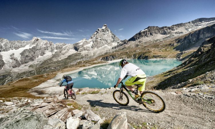
With an extensive network of unsurfaced tracks, ski resorts with lifts open in the summer and a leg of the Giro d’Italia often passing through it, the Aosta Valley is a great cycling destination. Whether it is mountain biking, road cycling or the more extreme downhill mountain biking, here is a sample of the tried and tested!
Often used as a leg of the Giro d’Italia tour, the Aosta Valley provides scenic and panoramic rides amidst spectacular scenery. There’s a great variety of road cycling routes, so we are giving you just a couple here:
Aosta to Courmayeur: Cycle through vineyards, medieval castles and ancient villages. Recommended time: 01/05 to 30/09. Elevation difference 615 m. Length 35.1 Km. Duration 1h16. Itinerary (elevation indicated in brackets): Aosta (585 m), Valle di Cogne junction 4.5 km (625 m), Rhemes/Valsavarenche junction 10.1 km (670m), Valgrisenche junction 13.7 km (745m), Strada dei Salassi junction 15.3 km (780m), Col San Carlo junction 24.9 km (920m), Pré-Saint-Didier – Little St Bernard Pass junction 29.7 km (1010m), Courmayeur 35.1 km (1200m).
A journey through monuments from the Roman period, Nus – producer of one of the finest white wines in Aosta Valley- and spectacular views over the main peaks of the Graian Alps. Recommended time: 01/05 to 31/10. Elevation difference: 1,095m. Length: 49,7Km. Duration: 3hours. Itinerary (elevation indicated in brackets): Villefranche 6.1 km (540m), Saint-Marcel junction 8.3 km (530m), Nus 10.1 km (545m), Petit Fénis 15.7 km (940m), Blavy 17.2 km (1,065m), Les Fabbriques 22.8 km (1,440m), Lignan 26.8 km (1,665m), Arlod 30.3 km (1,59 m), Efraz 32.1 km (1,495m), Villair Sur Nus 38 km (1,130m), Saint-Christophe junction 45.7 km (650m), Aosta 51.2 km (570m).
If your thing is more mountain biking, with over 1000 kilometres of unsurfaced tracks stemming from its agricultural traditions, Aosta Valley is the perfect territory. Mule tracks, farm roads and wooded paths offer you the opportunity to enjoy the valley’s ever-changing spectacular scenery and qualified mountain bike instructors are available. Ranging from easy to difficult here is a taster of what you can find:
Grand tour of the Cime Bianche Upper Hill: Departure /Arrival: Breuil-Cervinia (2000 mt.). Technical and physical difficulty: difficult. Bike-friendly: 90%. Recommended time: 01/06 to 31/10. Elevation difference: 980 m. Length: 18 Km. Type: mixed asphalt, dirt road, path. This route has a sequence of steep ascents, takes places in the Breuil basin and continues at high altitude and it offers vistas of the Rollin basin and the Gran Lago.
Ascent to the hill of the Monte Rosa Glaciers: Departure: Stafal (1850 mt.), Arrival Colle della Bettaforca (2,727 mt.). Technical and physical difficulty: Medium. Bike-friendly: 100%. Recommended time: 01/06 to 31/10. Elevation difference: 870 m. Length: 9 Km. Type: mixed asphalt, dirt road, path. A top route in terms of performance at high altitude due to the marked slope of the stretch, not very demanding. Offers fantastic views of the most beautiful peaks of the Monte Rosa group along with the Corno Bianco mountain range.
San Carlo Pass – Arpy Lake: Departure: Colle San Carlo (1951 mt), Arrival: Lago d’Arpy (2066 mt). Technical and physical difficulty: Easy. Bike-friendly: 100%. Recommended time: 01/06 to 30/09. Elevation difference: 115 m. Length: 5 Km. Type: dirt road. A beautiful cycle journey through larch woods, suitable for everyone, even families with children.
For those looking for a more extreme adventure, some of the local ski resorts (including Pila and La Thuile) keep their chairlifts and cable cars running throughout the summer, making them perfect locations for downhill cycling. In Pila, the Baby Gorraz area has a Bike Park with a range of options from basic practice for those new to downhill to freeride acrobatics, for expert use only! More info here.


